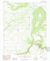
1986 Map of Sunset Pass
USGS Topo · Published 1986About this map
West Sunset Mountain and East Sunset Mountain dominate this high-desert landscape in the Coconino National Forest. The geography is defined by a series of critical water catchments, including the Upper Red Tank, Middle Red Tank, and Lower Red Tank, which were essential for ranching and wildlife in the arid climate of Northern Arizona during the 1980s. A notable prospect near the mountain slopes suggests historical mineral exploration, while the namesake Sunset Pass serves as a natural gateway between the peaks. The drainage patterns of Jacks Canyon and Limestone Wash channel water through the high country toward Clear Creek. This map captures a working landscape of ranching infrastructure, evidenced by labels like the Corral and numerous named stock tanks such as Fannin Tank and Dick Hart Tank.
Find a feature on this map
29 named features on this map. Tap any name to fly to it.
Don’t see what you’re looking for? This feature index may not catch every label — zoom into the map to look around manually.
Map Details
Editions of this 1986 Sunset Pass Map
This is the sole edition of this map. No revisions or reprints were ever made.
Other maps of this area

1886 · Holbrook
USGS Topo · 1:250,000

1887 · Verde
USGS Topo · 1:250,000

1892 · Verde
USGS Topo · 1:250,000

1893 · Holbrook
USGS Topo · 1:250,000

1954 · Holbrook
USGS Topo · 1:250,000

1955 · Sunset Knoll 2 SW
USGS Topo · 1:24,000
1955 · Sunset Knoll 2 NW
USGS Topo · 1:24,000

1955 · Sunset Knoll 2 SE
USGS Topo · 1:24,000

1955 · Sunset Pass
USGS Topo · 1:62,500

1957 · Holbrook
USGS Topo · 1:250,000