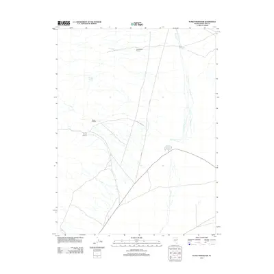
2012 Map of Sunset Reservoir
USGS Topo · Published 2012About this map
Sunset Reservoir and Robison Reservoir serve as the primary hydrologic focal points in this high-desert landscape of White Pine County. The terrain is defined by a series of drainages, most notably Chin Creek, which threads through the eastern portion of the quadrangle. Strategic water sources such as Cottonwood Spring and Tippett Springs are critical landmarks in this arid environment, often indicating historical stopping points or ranching activity. The western edge of the map is dominated by the complex topography of Cottonwood Canyon, Tunnel Canyon, and the appropriately named Secret Canyon. Transportation is limited to a sparse network of rural routes, including Tunnel Canyon Rd and Co Rd-33, which navigate the wide basins and descending canyons of the Great Basin.
Find a feature on this map
11 named features on this map. Tap any name to fly to it.
Don’t see what you’re looking for? This feature index may not catch every label — zoom into the map to look around manually.
Map Details
Editions of this 2012 Sunset Reservoir Map
This is the sole edition of this map. No revisions or reprints were ever made.
Other maps of this area

1955 · Elko
USGS Topo · 1:250,000

1956 · Ely
USGS Topo · 1:250,000

1958 · Elko
USGS Topo · 1:250,000

1959 · Ely
USGS Topo · 1:250,000

1962 · Elko
USGS Topo · 1:250,000

1963 · Ely
USGS Topo · 1:250,000

1965 · Elko
USGS Topo · 1:250,000

1979 · Sunset Reservoir
USGS Topo · 1:24,000
1981 · Tippett Canyon
USGS Topo · 1:24,000
1981 · Spring Creek Flat NW
USGS Topo · 1:24,000