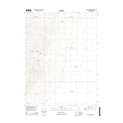
2014 Map of Sunset Reservoir
USGS Topo · Published 2014About this map
The Antelope Range dominates the western portion of this high-desert landscape in White Pine County, where steep drainages like Secret Canyon and Tunnel Canyon carve through the terrain. Evidence of land use is centered on the scarce water resources of the Great Basin, including Tippett Springs, Cottonwood Spring, and the namesake Sunset Reservoir to the east. A network of rural routes, including the descriptively named Whiskey Rd and Tunnel Canyon Rd, provides access across the valley floor. The presence of the Sellas One Hundred Fifty Two mine site suggests a history of mineral exploration or extraction typical of the region's scattered industrial footprint. Much of the area is defined by the ephemeral Chin Cr, which threads through the eastern flats near the junction of several county roads.
Find a feature on this map
19 named features on this map. Tap any name to fly to it.
Don’t see what you’re looking for? This feature index may not catch every label — zoom into the map to look around manually.
Map Details
Editions of this 2014 Sunset Reservoir Map
This is the sole edition of this map. No revisions or reprints were ever made.
Other maps of this area

1955 · Elko
USGS Topo · 1:250,000

1956 · Ely
USGS Topo · 1:250,000

1958 · Elko
USGS Topo · 1:250,000

1959 · Ely
USGS Topo · 1:250,000

1962 · Elko
USGS Topo · 1:250,000

1963 · Ely
USGS Topo · 1:250,000

1965 · Elko
USGS Topo · 1:250,000

1979 · Sunset Reservoir
USGS Topo · 1:24,000
1981 · Tippett Canyon
USGS Topo · 1:24,000
1981 · Spring Creek Flat NW
USGS Topo · 1:24,000