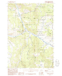
1986 Map of Sunshine Point
USGS Topo · Published 1987About this map
The Gallatin River carves a central path through this mountain landscape, marking a corridor defined by public lands and high-country landmarks. The 1986 survey highlights the intersection of the Gallatin National Forest with the Lee Metcalf Wilderness and the northwestern edge of Yellowstone National Park. This geography is characterized by its network of steep ridges and drainages, such as Cameron Ridge and Snowflake Ridge, where numerous seasonal and permanent water sources like Snowflake Springs and Cinnamon Creek feed the main river system.
Find a feature on this map
37 named features on this map. Tap any name to fly to it.
Don’t see what you’re looking for? This feature index may not catch every label — zoom into the map to look around manually.
Map Details
Editions of this 1986 Sunshine Point Map
2 editions found
Other maps of this area

1888 · Three Forks
USGS Topo · 1:250,000

1894 · Three Forks
USGS Topo · 1:250,000

1895 · Three Forks
USGS Topo · 1:250,000

1947 · Bozeman
USGS Topo · 1:250,000

1948 · Bozeman
USGS Topo · 1:250,000

1950 · Hebgen Dam
USGS Topo · 1:62,500

1950 · Sphinx Mountain
USGS Topo · 1:62,500

1955 · Bozeman
USGS Topo · 1:250,000

1955 · Crown Butte
USGS Topo · 1:62,500

1955 · Ashton
USGS Topo · 1:250,000