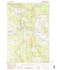
1986 Map of Sunshine Point
USGS Topo · Published 1987About this map
The Gallatin River carves a deep valley through this mountain landscape, serving as a primary corridor through the high country of southwest Montana. In the late 1980s, this area was defined by its overlapping conservation boundaries, where the Gallatin National Forest meets the northwest corner of Yellowstone National Park. To the south, the Lee Metcalf Wilderness preserves the high peaks near Monument Meadow. Topographical features like The Blowout and Pulpit Rock mark the steep ascent of Cameron Ridge above the river. This map shows a landscape largely shaped by natural landmarks and pack trails rather than roads, reflecting the remote character of the Gallatin State Wildlife Management Area and its surrounding wilderness at the time of the survey.
Find a feature on this map
28 named features on this map. Tap any name to fly to it.
Don’t see what you’re looking for? This feature index may not catch every label — zoom into the map to look around manually.
Map Details
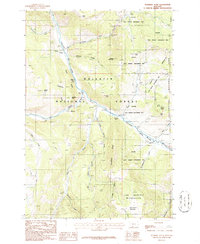
Editions of this 1986 Sunshine Point Map
2 editions found
Other maps of this area

1888 · Three Forks
USGS Topo · 1:250,000

1894 · Three Forks
USGS Topo · 1:250,000

1895 · Three Forks
USGS Topo · 1:250,000

1947 · Bozeman
USGS Topo · 1:250,000

1948 · Bozeman
USGS Topo · 1:250,000

1950 · Hebgen Dam
USGS Topo · 1:62,500

1950 · Sphinx Mountain
USGS Topo · 1:62,500

1955 · Bozeman
USGS Topo · 1:250,000

1955 · Crown Butte
USGS Topo · 1:62,500

1955 · Ashton
USGS Topo · 1:250,000