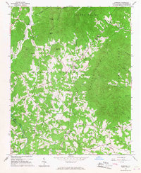
1965 Map of Sunshine
USGS Topo · Published 1967About this map
Logans Store and the surrounding foothill communities of Rutherford County are documented here during the mid-1960s, a period when the landscape was defined by small mountain settlements and a high density of rural churches. The settlement of Sunshine serves as a central point, anchored by the Cedar Grove Ch and Sunshine Ch, while the southern reaches of the South Mountains rise sharply to the north. Evidence of local industry and infrastructure includes the Adkins Mine tucked against the slopes and a small Landing Strip near the Second Broad River.
Find a feature on this map
49 named features on this map. Tap any name to fly to it.
Don’t see what you’re looking for? This feature index may not catch every label — zoom into the map to look around manually.
Map Details
Editions of this 1965 Sunshine Map
This is the sole edition of this map. No revisions or reprints were ever made.
Other maps of this area

1905 · Morganton
USGS Topo · 1:125,000

1950 · Shelby
USGS Topo · 1:62,500

1953 · Charlotte
USGS Topo · 1:250,000

1954 · Charlotte
USGS Topo · 1:250,000

1956 · Benn Knob
USGS Topo · 1:24,000

1960 · Charlotte
USGS Topo · 1:250,000

1962 · Charlotte
USGS Topo · 1:250,000
1962 · Glenwood
USGS Topo · 1:24,000
1962 · Dysartsville
USGS Topo · 1:24,000
1966 · Rutherfordton North
USGS Topo · 1:24,000