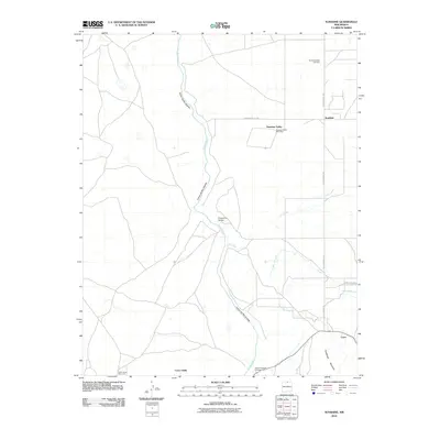
2010 Map of Sunshine
USGS Topo · Published 2010About this map
Sunshine Valley occupies a dramatic landscape where the high plateau meets the deep incision of the Cañon del Rio Grande. This northern New Mexico high-desert community is defined by its agricultural engineering, visible in the network of irrigation channels including Number One Ditch, Number Two Ditch, and Number Three Ditch that draw from Latir Creek. The settlement pattern is sparse, centered around the Sunshine Valley Post Office and the small residential cluster at Sunshine, while the Old Sunshine Hwy serves as a primary north-south artery.
Find a feature on this map
21 named features on this map. Tap any name to fly to it.
Don’t see what you’re looking for? This feature index may not catch every label — zoom into the map to look around manually.
Map Details
Editions of this 2010 Sunshine Map
This is the sole edition of this map. No revisions or reprints were ever made.
Other maps of this area

1954 · Raton
USGS Topo · 1:250,000

1958 · Raton
USGS Topo · 1:250,000

1963 · Costilla
USGS Topo · 1:24,000

1963 · Tres Piedras NE
USGS Topo · 1:24,000

1963 · Cerro De La Olla
USGS Topo · 1:24,000

1963 · Cerro
USGS Topo · 1:24,000

1963 · Ute Mountain
USGS Topo · 1:24,000

1963 · Sunshine
USGS Topo · 1:24,000
1963 · La Segita Peaks NE
USGS Topo · 1:24,000

1963 · Questa
USGS Topo · 1:24,000