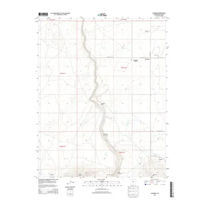
2013 Map of Sunshine
USGS Topo · Published 2013About this map
Rio Grande waters carve through the center of this high-desert landscape, defining the dramatic Cañon del Rio Grande corridor. To the east, the rural settlements of Sunshine and Sunshine Valley are situated along the Old Sunshine Hwy, supported by an irrigation network that includes Number One Ditch and Number Two Ditch. This 2013 survey illustrates a region where conservation and recreation overlap, as evidenced by the Rio Grande Wild River area and the Chiflo Game Water Unit. Further south, the community of Cerro sits at the foot of Guadalupe Mtn, where the terrain begins to rise sharply. Local history is anchored by the Sunshine Valley Cem and the local post office, marking the enduring presence of these northern New Mexico communities amidst the volcanic peaks of Cerro Chiflo.
Find a feature on this map
26 named features on this map. Tap any name to fly to it.
Don’t see what you’re looking for? This feature index may not catch every label — zoom into the map to look around manually.
Map Details
Editions of this 2013 Sunshine Map
This is the sole edition of this map. No revisions or reprints were ever made.
Other maps of this area

1954 · Raton
USGS Topo · 1:250,000

1958 · Raton
USGS Topo · 1:250,000

1963 · Costilla
USGS Topo · 1:24,000

1963 · Tres Piedras NE
USGS Topo · 1:24,000

1963 · Cerro De La Olla
USGS Topo · 1:24,000

1963 · Cerro
USGS Topo · 1:24,000

1963 · Ute Mountain
USGS Topo · 1:24,000

1963 · Sunshine
USGS Topo · 1:24,000
1963 · La Segita Peaks NE
USGS Topo · 1:24,000

1963 · Questa
USGS Topo · 1:24,000