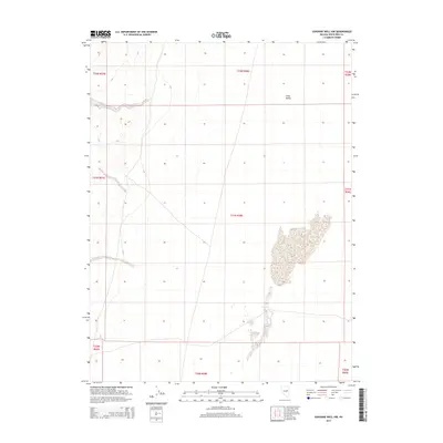
2014 Map of Sunshine Well NW
USGS Topo · Published 2014About this map
Long Valley dominates this high-altitude interior drainage basin in White Pine County, Nevada, as mapped in 2014. The landscape is characterized by a distinctive north-south trending valley floor, flanked by the gradual rise of surrounding terrain. Large, ephemeral alkaline flats or playa features occupy the lower elevations, particularly across t21n r58e and t20n r58e, reflecting the arid environment's intermittent drainage patterns. The map detail highlights the Public Land Survey System (PLSS) grid, documenting the township and range divisions such as t22n r58e that define land ownership and management in this part of the Great Basin. Remote and largely undeveloped, the area's few roads trace the natural contours of the valley, supporting localized land use far from the state's major population centers.
Find a feature on this map
10 named features on this map. Tap any name to fly to it.
Don’t see what you’re looking for? This feature index may not catch every label — zoom into the map to look around manually.
Map Details
Editions of this 2014 Sunshine Well NW Map
This is the sole edition of this map. No revisions or reprints were ever made.
Other maps of this area

1956 · Ely
USGS Topo · 1:250,000

1957 · Buck Mountain
USGS Topo · 1:62,500

1957 · Cold Creek Ranch
USGS Topo · 1:62,500

1959 · Ely
USGS Topo · 1:250,000

1963 · Ely
USGS Topo · 1:250,000
1982 · Cabin Spring
USGS Topo · 1:24,000
1982 · McBrides Sheep Well
USGS Topo · 1:24,000
1982 · Long Valley Slough
USGS Topo · 1:24,000

1982 · Dickenson Well
USGS Topo · 1:24,000

1982 · Sunshine Well
USGS Topo · 1:24,000