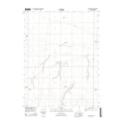
2014 Map of Sunshine Well
USGS Topo · Published 2014About this map
Long Valley stretches through this high-altitude basin in eastern Nevada, bounded by the northern reaches of the White Pine Range. The terrain is characterized by broad alluvial fans and drainage patterns that converge in the valley floor, reflecting the arid environment of the Great Basin. A critical landmark for those navigating this remote landscape is Sunshine Well, a named water source located in the northeastern portion of the quadrangle. The map details the Public Land Survey System grid across portions of t20n r58e and surrounding townships, providing precise coordinates for a region defined by its wide-open spaces and topographic isolation. This 2014 survey documents the enduring spatial layout of the county's interior, where historical land divisions and vital water points remain the primary markers of human presence.
Find a feature on this map
9 named features on this map. Tap any name to fly to it.
Don’t see what you’re looking for? This feature index may not catch every label — zoom into the map to look around manually.
Map Details
Editions of this 2014 Sunshine Well Map
This is the sole edition of this map. No revisions or reprints were ever made.
Other maps of this area

1951 · Illipah
USGS Topo · 1:62,500

1951 · Pancake Summit
USGS Topo · 1:62,500

1956 · Ely
USGS Topo · 1:250,000

1957 · Buck Mountain
USGS Topo · 1:62,500

1959 · Ely
USGS Topo · 1:250,000

1963 · Ely
USGS Topo · 1:250,000

1979 · Mt. Hamilton
USGS Topo · 1:100,000
1982 · McBrides Sheep Well
USGS Topo · 1:24,000

1982 · Dickenson Well
USGS Topo · 1:24,000

1982 · Sunshine Well
USGS Topo · 1:24,000