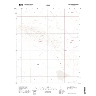
2018 Map of Superstition Mountain
USGS Topo · Published 2018About this map
Superstition Mtn rises as the dominant landmark in this arid portion of Imperial County, California. This desert landscape is characterized by the broad expanse of West Mesa to the west and the transition into the fertile lowlands of the Imperial Valley to the east. The land is strictly organized by the Public Land Survey System, with township boundaries such as t14s r11e and t14s r12e marking the desert floor. Remote access through this region is defined by corridors like Imler Rd and Wheeler Rd, which skirt the southern reaches of the mountain. This survey captures the isolated character of the Colorado Desert region before the continued expansion of irrigation and agricultural developments further transformed the surrounding valley floor.
Find a feature on this map
11 named features on this map. Tap any name to fly to it.
Don’t see what you’re looking for? This feature index may not catch every label — zoom into the map to look around manually.
Map Details
Editions of this 2018 Superstition Mountain Map
This is the sole edition of this map. No revisions or reprints were ever made.
Other maps of this area

1915 · El Centro
USGS Topo · 1:125,000

1940 · Brawley
USGS Topo · 1:62,500

1940 · Kane Spring
USGS Topo · 1:62,500

1940 · Plaster City
USGS Topo · 1:62,500

1942 · El Centro
USGS Topo · 1:250,000

1943 · Brawley
USGS Topo · 1:62,500

1944 · Plaster City
USGS Topo · 1:62,500

1944 · Kane Spring
USGS Topo · 1:62,500

1944 · Calipatria
USGS Topo · 1:62,500

1954 · El Centro
USGS Topo · 1:250,000