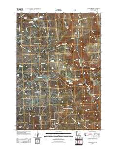
2011 Map of Suplee Butte
USGS Topo · Published 2011About this map
The South Fork John Day River winds through this Grant County landscape, providing the primary drainage for an area defined by its early industrial and agricultural footprints. Notable landmarks like Ellingson Mill and Bernard Mill speak to the region's historical timber or milling activities, while named sites such as the Robinsin Homestead and Negro Cabin offer specific points of interest for genealogists and local historians. The terrain is a complex network of canyons and high ground, featuring elevations like Suplee Butte, Little Baldy, and Sugarloaf Mountain.
Find a feature on this map
58 named features on this map. Tap any name to fly to it.
Don’t see what you’re looking for? This feature index may not catch every label — zoom into the map to look around manually.
Map Details
Editions of this 2011 Suplee Butte Map
This is the sole edition of this map. No revisions or reprints were ever made.
Other maps of this area

1932 · Dayville
USGS Topo · 1:125,000

1936 · Dayville
USGS Topo · 1:125,000

1940 · Aldrich Mtn.
USGS Topo · 1:62,500

1943 · Aldrich Mtn.
USGS Topo · 1:62,500

1955 · Canyon City
USGS Topo · 1:250,000

1959 · Canyon City
USGS Topo · 1:250,000

1961 · Izee
USGS Topo · 1:62,500

1972 · Wolf Mountain
USGS Topo · 1:24,000
1972 · Aldrich Gulch
USGS Topo · 1:24,000
1972 · Aldrich Mountain South
USGS Topo · 1:24,000