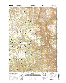
2017 Map of Suplee Butte
USGS Topo · Published 2017About this map
Ochoco National Forest defines the character of this high-elevation landscape in eastern Oregon, where a sophisticated network of resource management and water conservation features is visible. The terrain is marked by distinctive volcanic and erosional features such as Suplee Butte, Spur Butte, and the prominent Sugarloaf Mtn. This late 20th-century landscape is dominated by an extensive system of catchments and named springs, including Greenwater Reservoir, Art Reservoir, and Blue-Pot Spring, which illustrate the critical importance of water management in this arid timber and grazing region.
Find a feature on this map
87 named features on this map. Tap any name to fly to it.
Don’t see what you’re looking for? This feature index may not catch every label — zoom into the map to look around manually.
Map Details
Editions of this 2017 Suplee Butte Map
This is the sole edition of this map. No revisions or reprints were ever made.
Other maps of this area

1932 · Dayville
USGS Topo · 1:125,000

1936 · Dayville
USGS Topo · 1:125,000

1940 · Aldrich Mtn.
USGS Topo · 1:62,500

1943 · Aldrich Mtn.
USGS Topo · 1:62,500

1955 · Canyon City
USGS Topo · 1:250,000

1959 · Canyon City
USGS Topo · 1:250,000

1961 · Izee
USGS Topo · 1:62,500

1972 · Wolf Mountain
USGS Topo · 1:24,000
1972 · Aldrich Gulch
USGS Topo · 1:24,000
1972 · Aldrich Mountain South
USGS Topo · 1:24,000