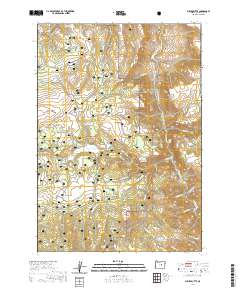
2020 Map of Suplee Butte
USGS Topo · Published 2020About this map
Ochoch National Forest lands dominate this central Oregon landscape, where the high-altitude terrain of the Blue Mountains is marked by numerous peaks and managed rangelands. The topography is defined by prominent rises like Suplee Butte and Sugarloaf Mtn, alongside expansive flats used for grazing, such as Cinnabar Flat and Murray Flat. Historically, the area reflects a reliance on seasonal water management, evident in the density of small basins and catchments like Cayuse Reservoir, Viewpoint Reservoir, and Hardscrabble Reservoir. A network of forest development routes and historic pathways, including the curiously named Santa Claus Sta Trail, weave through the timber and rimrock, connecting isolated springs like Blue-Pot Spring and Hobble Spring to the higher elevations of Hardscrabble Ridge.
Find a feature on this map
64 named features on this map. Tap any name to fly to it.
Don’t see what you’re looking for? This feature index may not catch every label — zoom into the map to look around manually.
Map Details
Editions of this 2020 Suplee Butte Map
This is the sole edition of this map. No revisions or reprints were ever made.
Other maps of this area

1932 · Dayville
USGS Topo · 1:125,000

1936 · Dayville
USGS Topo · 1:125,000

1940 · Aldrich Mtn.
USGS Topo · 1:62,500

1943 · Aldrich Mtn.
USGS Topo · 1:62,500

1955 · Canyon City
USGS Topo · 1:250,000

1959 · Canyon City
USGS Topo · 1:250,000

1961 · Izee
USGS Topo · 1:62,500

1972 · Wolf Mountain
USGS Topo · 1:24,000
1972 · Aldrich Gulch
USGS Topo · 1:24,000
1972 · Aldrich Mountain South
USGS Topo · 1:24,000