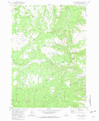
1981 Map of Suplee Butte
USGS Topo · Published 1981About this map
The Och Oco National Forest in central Oregon is defined by its network of water management features and high-altitude terrain in this 1981 survey. Significant infrastructure for ranching or forestry is evident through numerous reservoirs such as Hardscrabble Reservoir, Big Mowich Reservoir, and Porcupine Reservoir. The landscape is a complex system of ridges and flats, including Railroad Ridge, Hardscrabble Ridge, and Sunflower Flat, providing a glimpse into the land-use patterns of Grant County during the late 20th century. Local history and industry are represented by the Robinson Homestead and the sites of timber-related operations like Ellingson Mill and the Bernard Mill (Site). Natural landmarks like the South Fork Falls along the John Day River and whimsically named water sources such as Santa Claus Spring and Blue Pot Spring reflect a geography deeply mapped for its resources and recreational potential.
Find a feature on this map
67 named features on this map. Tap any name to fly to it.
Don’t see what you’re looking for? This feature index may not catch every label — zoom into the map to look around manually.
Map Details
Editions of this 1981 Suplee Butte Map
This is the sole edition of this map. No revisions or reprints were ever made.
Other maps of this area

1932 · Dayville
USGS Topo · 1:125,000

1936 · Dayville
USGS Topo · 1:125,000

1940 · Aldrich Mtn.
USGS Topo · 1:62,500

1943 · Aldrich Mtn.
USGS Topo · 1:62,500

1955 · Canyon City
USGS Topo · 1:250,000

1959 · Canyon City
USGS Topo · 1:250,000

1961 · Izee
USGS Topo · 1:62,500

1972 · Wolf Mountain
USGS Topo · 1:24,000
1972 · Aldrich Gulch
USGS Topo · 1:24,000
1972 · Aldrich Mountain South
USGS Topo · 1:24,000