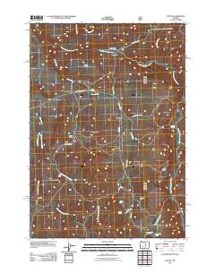
2011 Map of Suplee
USGS Topo · Published 2011About this map
The settlement of Suplee serves as the central hub of this remote high-desert landscape, where ranching and natural springs define the human presence. Scattered across the drainage basins of Camp Creek and South Fork Beaver Creek, working homesteads like Bernard Ranch and Robertson Ranch indicate a long-standing agricultural tradition. The terrain is marked by distinctive geological formations, from the flat-topped Soda Table to the prominent Colpitts Butte, which rise above the surrounding basins. Water is a critical resource in this arid environment, evidenced by the numerous named water sources such as Soda Spring, Delore Spring, and the geothermal activity at Suplee Hot Spring. These points of interest, connected by routes like the Paulina Suplee Hwy, illustrate how early 21st-century land use in Crook County remained closely tied to the region's unique hydrology and topography.
Find a feature on this map
29 named features on this map. Tap any name to fly to it.
Don’t see what you’re looking for? This feature index may not catch every label — zoom into the map to look around manually.
Map Details
Editions of this 2011 Suplee Map
This is the sole edition of this map. No revisions or reprints were ever made.
Other maps of this area

1932 · Dayville
USGS Topo · 1:125,000

1936 · Dayville
USGS Topo · 1:125,000

1955 · Burns
USGS Topo · 1:250,000

1955 · Canyon City
USGS Topo · 1:250,000

1958 · Burns
USGS Topo · 1:250,000

1959 · Burns
USGS Topo · 1:250,000

1959 · Canyon City
USGS Topo · 1:250,000

1961 · Delintment Lake
USGS Topo · 1:62,500
1981 · Powell Mtn
USGS Topo · 1:24,000

1981 · Suplee
USGS Topo · 1:24,000