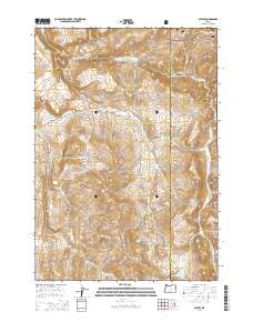
2014 Map of Suplee
USGS Topo · Published 2014About this map
Suplee and the high desert interior of Central Oregon are mapped here along the border of Crook and Grant Counties. This landscape is defined by its hydrology and high elevations, where cattle ranching and early settlements like Miners Flat found purchase near reliable water sources. The map records numerous geothermal and freshwater points, including Suplee Hot Spring, Soda Spring, and Henshaw Spring, which historically supported livestock and travelers in this arid region. High points such as Colpitts Butte and the broad Soda Table overlook a drainage network that feeds into Rock Cr and S Fork Beaver Cr. The northern edge of the sheet transitions into the Ochoco National Forest, while the south is marked by prominent family-named landmarks like Weberg Butte and Pitt Butte.
Find a feature on this map
34 named features on this map. Tap any name to fly to it.
Don’t see what you’re looking for? This feature index may not catch every label — zoom into the map to look around manually.
Map Details
Editions of this 2014 Suplee Map
This is the sole edition of this map. No revisions or reprints were ever made.
Other maps of this area

1932 · Dayville
USGS Topo · 1:125,000

1936 · Dayville
USGS Topo · 1:125,000

1955 · Burns
USGS Topo · 1:250,000

1955 · Canyon City
USGS Topo · 1:250,000

1958 · Burns
USGS Topo · 1:250,000

1959 · Burns
USGS Topo · 1:250,000

1959 · Canyon City
USGS Topo · 1:250,000

1961 · Delintment Lake
USGS Topo · 1:62,500
1981 · Powell Mtn
USGS Topo · 1:24,000

1981 · Suplee
USGS Topo · 1:24,000