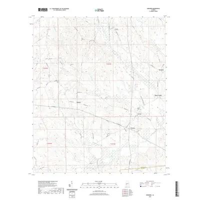
2020 Map of Surginer
USGS Topo · Published 2020About this map
Surginer and Vineland anchor this section of Marengo County, where the landscape is defined by a dense network of creek drainages including Turkey Cr, Cypress Cr, and Baptizing Cr. The settlement pattern is largely rural, clustered along AL Highway 10 and a series of county roads that connect remote homesteads and local landmarks. This area shows a significant concentration of community burial sites and small rural congregations, such as Wesley Chapel Cem, Christian Hope Cem, and Friendship Baptist Church Cem, which serve as vital touchpoints for genealogical research. The map captures the intersection of traditional land divisions like t13n r4e and the Marengo and Wilcox County line, documenting the persistent rural character of southwest Alabama.
Find a feature on this map
71 named features on this map. Tap any name to fly to it.
Don’t see what you’re looking for? This feature index may not catch every label — zoom into the map to look around manually.
Map Details
Editions of this 2020 Surginer Map
This is the sole edition of this map. No revisions or reprints were ever made.
Other maps of this area

1953 · Montgomery
USGS Topo · 1:250,000

1953 · Andalusia
USGS Topo · 1:250,000

1956 · Montgomery
USGS Topo · 1:250,000

1957 · Montgomery
USGS Topo · 1:250,000

1957 · Andalusia
USGS Topo · 1:250,000

1973 · Pine Hill
USGS Topo · 1:24,000

1973 · Thomasville
USGS Topo · 1:24,000

1978 · Surginer
USGS Topo · 1:24,000

1978 · Sweet Water
USGS Topo · 1:24,000
1978 · Bashi
USGS Topo · 1:24,000