
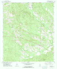
1978 Map of Surginer
USGS Topo · Published 1979About this map
Small rural crossroads and scattered church congregations define the landscape along the Marengo Co Wilcox Co line in the late 1970s. The settlement of Surginer serves as a central point, anchored by the Union Grove Ch and nearby Sandpit and Claypits extractions. Further south, the village of Vineland marks a junction near the banks of Piney Woods Creek, while Magnolia Terminal sits to the north where the St Louis-San Francisco railroad cuts through the terrain.
Find a feature on this map
31 named features on this map. Tap any name to fly to it.
Don’t see what you’re looking for? This feature index may not catch every label — zoom into the map to look around manually.
Map Details
Editions of this 1978 Surginer Map
2 editions found
Other maps of this area

1953 · Montgomery
USGS Topo · 1:250,000

1953 · Andalusia
USGS Topo · 1:250,000

1956 · Montgomery
USGS Topo · 1:250,000

1957 · Montgomery
USGS Topo · 1:250,000

1957 · Andalusia
USGS Topo · 1:250,000

1973 · Pine Hill
USGS Topo · 1:24,000

1973 · Thomasville
USGS Topo · 1:24,000

1978 · Sweet Water
USGS Topo · 1:24,000
1978 · Bashi
USGS Topo · 1:24,000
1978 · Flatwood
USGS Topo · 1:24,000