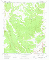
1971 Map of Surrender Canyon
USGS Topo · Published 1975About this map
The Navajo Indian Reservation dominates this landscape, straddling the high desert boundary where Arizona meets New Mexico. Much of the terrain is defined by dramatic erosional features like Oak Spring Valley and the eponymous Surrender Canyon, which cuts through the sandstone towards the Puerco River. Water management and transportation are central to the area's layout, seen in the Gaging Station on Black Creek and the heavy transit corridor in the southeast. Here, the tracks of the Atchison Topeka and Santa Fe railroad run parallel to the modern highway infrastructure, including Bowman Memorial Park (Rest Area). A network of Jeep Trails provides the primary access to the interior plateaus and peaks like Tea Pot, reflecting a landscape that remained largely undeveloped and focused on cattle grazing and transit during the early 1970s.
Find a feature on this map
15 named features on this map. Tap any name to fly to it.
Don’t see what you’re looking for? This feature index may not catch every label — zoom into the map to look around manually.
Map Details
Editions of this 1971 Surrender Canyon Map
This is the sole edition of this map. No revisions or reprints were ever made.
Other maps of this area

1886 · Wingate
USGS Topo · 1:250,000

1886 · Fort Defiance
USGS Topo · 1:250,000

1892 · Fort Defiance
USGS Topo · 1:250,000

1892 · Wingate
USGS Topo · 1:250,000

1954 · Gallup
USGS Topo · 1:250,000

1958 · Gallup
USGS Topo · 1:250,000

1959 · Gallup
USGS Topo · 1:250,000

1962 · Gallup
USGS Topo · 1:250,000

1963 · Manuelito
USGS Topo · 1:24,000

1963 · Jones Ranch School
USGS Topo · 1:24,000