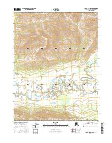
2016 Map of Survey Pass A-6 SW
USGS Topo · Published 2016About this map
The Mauneluk River meanders through this remote portion of the Northwest Arctic Borough, creating a complex network of oxbows and wetlands. The landscape is characterized by a dramatic contrast between the high mountainous terrain in the northern sections and the intricate river valley below. Near the eastern edge of the survey area, Avaraart Lake sits amidst the floodplain, highlighting the water-rich geography of the region. This 2016 topographic study captures the precise township and range boundaries for t20n r13e, t20n r14e, t19n r13e, and t19n r14e, documenting the land divisions used by the Bureau of Land Management to manage this wilderness area. The detailed contouring illustrates the sharp descent from the northern peaks into the riparian basin of the Mauneluk.
Find a feature on this map
6 named features on this map. Tap any name to fly to it.
Don’t see what you’re looking for? This feature index may not catch every label — zoom into the map to look around manually.
Map Details
Editions of this 2016 Survey Pass A-6 SW Map
This is the sole edition of this map. No revisions or reprints were ever made.
Other maps of this area

1951 · Shungnak
USGS Topo · 1:250,000

1951 · Hughes
USGS Topo · 1:250,000

1951 · Survey Pass
USGS Topo · 1:250,000

1951 · Ambler River
USGS Topo · 1:250,000

1955 · Shungnak
USGS Topo · 1:250,000

1956 · Hughes
USGS Topo · 1:250,000

1956 · Survey Pass
USGS Topo · 1:250,000

1956 · Ambler River
USGS Topo · 1:250,000

1964 · Survey Pass
USGS Topo · 1:250,000

1964 · Shungnak
USGS Topo · 1:250,000