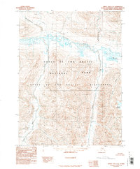
1990 Map of Survey Pass C-6
USGS Topo · Published 1990About this map
Gates of the Arctic National Park dominates this northern Alaskan interior, where the Noatak River serves as the primary drainage for a landscape defined by sharp alpine peaks and glacial valleys. Compiled from aerial photography taken in 1979 and 1980, the map illustrates the hydrology of the Brooks Range, centered around the Gates of the Arctic Wilderness designation. To the south, the Igning River and Kugrak River carve through high-altitude terrain near Oyukak Mountain. Significant water features such as Lake Omelaktavik and the winding Nigikpalugururak Creek provide essential reference points for this roadless territory. The survey indicates a region managed entirely for conservation and natural processes, reflecting its status just after the establishment of the national park boundaries.
Find a feature on this map
10 named features on this map. Tap any name to fly to it.
Don’t see what you’re looking for? This feature index may not catch every label — zoom into the map to look around manually.
Map Details
Editions of this 1990 Survey Pass C-6 Map
This is the sole edition of this map. No revisions or reprints were ever made.
Other maps of this area

1951 · Survey Pass
USGS Topo · 1:250,000

1951 · Ambler River
USGS Topo · 1:250,000

1956 · Survey Pass
USGS Topo · 1:250,000

1956 · Ambler River
USGS Topo · 1:250,000

1964 · Survey Pass
USGS Topo · 1:250,000

1964 · Ambler River
USGS Topo · 1:250,000

1966 · Survey Pass
USGS Topo · 1:250,000
1984 · Survey Pass D-6
USGS Topo · 1:63,360
1986 · Survey Pass D-5
USGS Topo · 1:63,360
1990 · Ambler River C-1
USGS Topo · 1:63,360