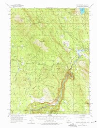
1955 Map of Surveyor Mtn
USGS Topo · Published 1975About this map
Surveyor Peak and Buck Mtn dominate this 1955 survey of the southern Cascade Range, where the high-altitude terrain transitions into the water-rich basin of the Klamath River. The map captures a mid-century landscape defined by logging and ranching operations, most notably the Lumber Railroad snaking through the Winema National Forest and the isolated 41 Ranch near the California border. A network of early motor ways, including the Green Springs Highway and Hayden Mountain Road, provides the primary connective tissue for this timber-producing region.
Find a feature on this map
64 named features on this map. Tap any name to fly to it.
Don’t see what you’re looking for? This feature index may not catch every label — zoom into the map to look around manually.
Map Details
Editions of this 1955 Surveyor Mtn Map
3 editions found

Other maps of this area

1886 · Modoc Lava Bed
USGS Topo · 1:250,000

1886 · Shasta
USGS Topo · 1:250,000

1889 · Klamath
USGS Topo · 1:250,000

1891 · Ashland
USGS Topo · 1:250,000

1892 · Modoc Lava-Bed
USGS Topo · 1:250,000

1893 · Ashland
USGS Topo · 1:250,000

1894 · Klamath
USGS Topo · 1:250,000

1894 · Shasta
USGS Topo · 1:250,000

1897 · Ashland
USGS Topo · 1:250,000

1934 · Macdoel
USGS Topo · 1:96,000