1992 Map of Suwanee
USGS Topo · Published 1993About this map
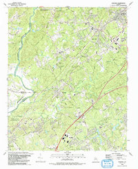
The Chattahoochee River winds along the western edge of this Gwinnett County landscape, defining the boundaries between Forsyth and Fulton counties during the early 1990s. The map captures a period of suburban expansion centered around Suwanee, Sugar Hill, and Buford, where established transportation corridors like the Southern Railway and Peachtree Road continue to anchor the region's geography. This survey provides a detailed look at the area's local history through numerous family and community landmarks, such as Hillcrest Cem, Old Suwanee Ch, and the Lockridge Cem. Natural drainage is dominated by the branching networks of Suwanee Creek and Level Creek, while public spaces like the Chattahoochee River National Recreation Area and George Pierce County Park preserve significant green space amidst the growing residential grid.
Find a feature on this map
77 named features on this map. Tap any name to fly to it.
Don’t see what you’re looking for? This feature index may not catch every label — zoom into the map to look around manually.
Map Details
Editions of this 1992 Suwanee Map
This is the sole edition of this map. No revisions or reprints were ever made.
Other maps of this area

1888 · Atlanta
USGS Topo · 1:125,000

1890 · Suwanee
USGS Topo · 1:125,000

1890 · Atlanta
USGS Topo · 1:125,000

1891 · Gainesville
USGS Topo · 1:125,000

1892 · Atlanta
USGS Topo · 1:125,000

1894 · Suwanee
USGS Topo · 1:125,000

1895 · Atlanta
USGS Topo · 1:125,000

1896 · Monroe
USGS Topo · 1:125,000

1953 · Atlanta
USGS Topo · 1:250,000

1953 · Athens
USGS Topo · 1:250,000