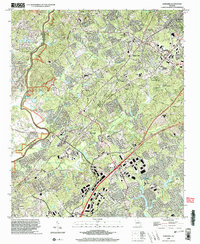
1999 Map of Suwanee
USGS Topo · Published 2003About this map
Sugar Hill and Suwanee are the primary hubs of this North Georgia landscape as it transitioned at the end of the twentieth century. The map tracks the dense network of roadways and residential expansion along the Peachtree Industrial Blvd corridor, juxtaposed against the natural preservation of the Chattahoochee River Nat Rec Area to the west. Genealogists will find a wealth of local burial sites, including the Riverside Cem, Lockridge Cem, and Strickland Cem. The terrain is characterized by the prominent Hog Mountain and numerous watercourses like Suwanee Creek and Ivy Creek that feed into the Chattahoochee River. This edition captures the area's development patterns while still recording older landmarks such as Carrols Crossing and Old Peachtree Ch.
Find a feature on this map
54 named features on this map. Tap any name to fly to it.
Don’t see what you’re looking for? This feature index may not catch every label — zoom into the map to look around manually.
Map Details
Editions of this 1999 Suwanee Map
This is the sole edition of this map. No revisions or reprints were ever made.
Other maps of this area

1888 · Atlanta
USGS Topo · 1:125,000

1890 · Suwanee
USGS Topo · 1:125,000

1890 · Atlanta
USGS Topo · 1:125,000

1891 · Gainesville
USGS Topo · 1:125,000

1892 · Atlanta
USGS Topo · 1:125,000

1894 · Suwanee
USGS Topo · 1:125,000

1895 · Atlanta
USGS Topo · 1:125,000

1896 · Monroe
USGS Topo · 1:125,000

1953 · Atlanta
USGS Topo · 1:250,000

1953 · Athens
USGS Topo · 1:250,000