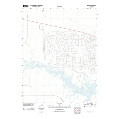
2010 Map of Swallows
USGS Topo · Published 2010About this map
Arkansas River hydrology and the expansion of the Pueblo Reservoir define this portion of Pueblo County in the early twenty-first century. The settlement of Swallows and the nearby Swallows Cemetery sit north of the river, where the landscape transitions from the riparian corridor to the residential street networks of the surrounding hills. Water management for the region is clearly visible through the Minnequa Canal and Teller Ditch, which trace the contours of the land to divert resources from natural drainages like Turkey Creek and Peck Creek. This area serves as a significant recreational and ecological hub, evidenced by the extensive acreage of Pueblo State Park and the specialized infrastructure of Pueblo Marina Access Rd. The map illustrates the contemporary balance between residential development, historical sites, and the vital water systems that sustain the high plains.
Find a feature on this map
27 named features on this map. Tap any name to fly to it.
Don’t see what you’re looking for? This feature index may not catch every label — zoom into the map to look around manually.
Map Details
Editions of this 2010 Swallows Map
This is the sole edition of this map. No revisions or reprints were ever made.
Other maps of this area

1891 · Pueblo
USGS Topo · 1:125,000

1894 · Pueblo
USGS Topo · 1:125,000

1896 · Pueblo
USGS Topo · 1:125,000

1897 · Pueblo
USGS Topo · 1:125,000

1954 · Pueblo
USGS Topo · 1:250,000

1957 · Pueblo
USGS Topo · 1:250,000

1958 · Pueblo
USGS Topo · 1:250,000
1961 · Steele Hollow
USGS Topo · 1:24,000

1961 · Northwest Pueblo
USGS Topo · 1:24,000

1961 · Southwest Pueblo
USGS Topo · 1:24,000