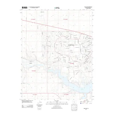
2013 Map of Swallows
USGS Topo · Published 2013About this map
Pueblo West dominates the northeastern landscape of this map, showcasing an extensive planned residential street network that includes S Conquistador Ave and W McCulloch Blvd. This modern development contrasts with the older settlement of Swallows to the west, located near the Swallows Cem above the Arkansas River. The southern portion of the quadrangle is defined by the significant waters of the Pueblo Reservoir, which is fed by drainage systems including Turkey Cr and Peck Cr. A complex of access routes such as Pueblo Reservoir Access Rd and Pueblo Marina Access Rd serve the recreational infrastructure within Pueblo State Park. The terrain shifts from the managed waters of the Minnequa Canal to the open land of Pumpkin Hollow in the north, reflecting a region defined by contemporary suburban growth and critical water management.
Find a feature on this map
119 named features on this map. Tap any name to fly to it.
Don’t see what you’re looking for? This feature index may not catch every label — zoom into the map to look around manually.
Map Details
Editions of this 2013 Swallows Map
This is the sole edition of this map. No revisions or reprints were ever made.
Other maps of this area

1891 · Pueblo
USGS Topo · 1:125,000

1894 · Pueblo
USGS Topo · 1:125,000

1896 · Pueblo
USGS Topo · 1:125,000

1897 · Pueblo
USGS Topo · 1:125,000

1954 · Pueblo
USGS Topo · 1:250,000

1957 · Pueblo
USGS Topo · 1:250,000

1958 · Pueblo
USGS Topo · 1:250,000
1961 · Steele Hollow
USGS Topo · 1:24,000

1961 · Northwest Pueblo
USGS Topo · 1:24,000

1961 · Southwest Pueblo
USGS Topo · 1:24,000