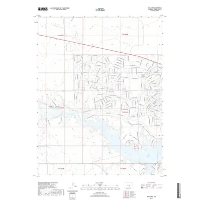
2019 Map of Swallows
USGS Topo · Published 2019About this map
Swallows and its surrounding drainage systems define this section of the Colorado landscape along the Arkansas River. The settlement pattern is largely shaped by modern residential development in the northern hills, where an intricate network of named roads like W Moccasin Dr and S Conquistador Ave winds through the terrain. To the south, the massive Pueblo Reservoir dominates the geography, fed by several significant watercourses including Turkey Cr, Peck Cr, and Rush Cr. Local heritage is anchored at the Swallows Cem and the Ecumenical Church Columbarium, which provide vital touchpoints for genealogical research. The Minnequa Canal and various railroad maintenance roads indicate the ongoing importance of water management and transportation infrastructure in managing the flow through Pumpkin Hollow toward the reservoir.
Find a feature on this map
175 named features on this map. Tap any name to fly to it.
Don’t see what you’re looking for? This feature index may not catch every label — zoom into the map to look around manually.
Map Details
Editions of this 2019 Swallows Map
This is the sole edition of this map. No revisions or reprints were ever made.
Other maps of this area

1891 · Pueblo
USGS Topo · 1:125,000

1894 · Pueblo
USGS Topo · 1:125,000

1896 · Pueblo
USGS Topo · 1:125,000

1897 · Pueblo
USGS Topo · 1:125,000

1954 · Pueblo
USGS Topo · 1:250,000

1957 · Pueblo
USGS Topo · 1:250,000

1958 · Pueblo
USGS Topo · 1:250,000
1961 · Steele Hollow
USGS Topo · 1:24,000

1961 · Northwest Pueblo
USGS Topo · 1:24,000

1961 · Southwest Pueblo
USGS Topo · 1:24,000