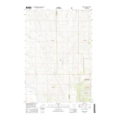
2017 Map of Swamp Creek
USGS Topo · Published 2017About this map
Beaverhead National Forest land dominates the southeastern portion of this terrain, where the Snowcrest Range rises toward a natural pass known as The Notch. This high-country landscape is defined by its complex drainage network, where waters from Swamp Creek and the E Fork Blacktail Deer Cr flow through deeply carved valleys. The boundary between Beaverhead and Madison Counties bisects the region, following a north-south line through the center of the survey. Isolated landmarks like Notch Station suggest the limited human infrastructure in this wilderness area, which is primarily accessed by unpaved routes such as Rock Creek Rd and Robb Creek Rd. Seasonal water sources including Poison Spring and Kelly Spring are critical points for local geography in the otherwise arid Dry Hollow area.
Find a feature on this map
21 named features on this map. Tap any name to fly to it.
Don’t see what you’re looking for? This feature index may not catch every label — zoom into the map to look around manually.
Map Details
Editions of this 2017 Swamp Creek Map
This is the sole edition of this map. No revisions or reprints were ever made.
Other maps of this area

1893 · Dillon
USGS Topo · 1:250,000

1955 · Dubois
USGS Topo · 1:250,000

1955 · Dillon
USGS Topo · 1:250,000

1957 · Dillon
USGS Topo · 1:250,000

1958 · Dubois
USGS Topo · 1:250,000

1958 · Dillon
USGS Topo · 1:250,000

1961 · Red Canyon
USGS Topo · 1:24,000

1962 · Dillon
USGS Topo · 1:250,000
1963 · Home Park Ranch
USGS Topo · 1:24,000
1963 · Belmont Park Ranch
USGS Topo · 1:24,000