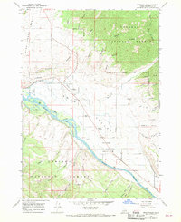
1966 Map of Swan Valley
USGS Topo · Published 1969About this map
The Snake River carves a significant course through this portion of eastern Idaho, defining the settlement patterns of Swan Valley and Irwin. This mid-1960s survey reveals a landscape where river-bottom agriculture and small-town life meet the protected timberlands of the Targhee National Forest to the north and the Caribou National Forest to the south. Local landmarks like the Chapel in the Valley and the Swan Valley Cemetery anchor the community, while the presence of several Storage Bins and a Gravel Pit along the riverbanks points to a local economy tied to both the land and the water. The intricate network of pack and jeep trails, such as those winding near Indian Creek, illustrates how the community historically accessed the surrounding canyons like Rainey Creek and Limekiln Canyon for ranching and resource management.
Find a feature on this map
45 named features on this map. Tap any name to fly to it.
Don’t see what you’re looking for? This feature index may not catch every label — zoom into the map to look around manually.
Map Details
Editions of this 1966 Swan Valley Map
Other maps of this area

1932 · Irwin
USGS Topo · 1:96,000

1935 · Irwin
USGS Topo · 1:125,000

1943 · Driggs
USGS Topo · 1:62,500

1943 · Garns Mtn
USGS Topo · 1:62,500

1946 · Driggs
USGS Topo · 1:62,500

1946 · Garns Mtn
USGS Topo · 1:62,500

1955 · Driggs
USGS Topo · 1:250,000

1958 · Driggs
USGS Topo · 1:250,000

1962 · Driggs
USGS Topo · 1:250,000

1966 · Conant Valley
USGS Topo · 1:24,000