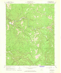
1967 Map of Swandale
USGS Topo · Published 1968About this map
Buffalo Creek carves a winding path through this portion of Clay County, anchoring a landscape where timber and resource extraction shaped the local communities. The settlement of Swandale sits along the northern banks, connected by rail and road to Cressmont and Eakle downstream. The mapping of this era shows a transition from deep valley settlements to the high, narrow ridges of Duffy Ridge and Pond Ridge, the latter featuring a Lookout Tower overlooking the surrounding drainages. Remote homesteads and community centers are preserved here through several landmark houses of worship, including Pleasant Dale Ch, New Antioch Ch, and Mt Oria Ch. The rugged terrain is further marked by local family history, with small burial sites like Ramsey Cem, Kyle Cem, and Wilson Cem situated near the headwaters of numerous forks and runs that feed into the larger creek systems.
Find a feature on this map
52 named features on this map. Tap any name to fly to it.
Don’t see what you’re looking for? This feature index may not catch every label — zoom into the map to look around manually.
Map Details
Editions of this 1967 Swandale Map
2 editions found
Other maps of this area

1889 · Nicholas
USGS Topo · 1:125,000

1891 · Nicholas
USGS Topo · 1:125,000

1893 · Sutton
USGS Topo · 1:125,000

1897 · Kanawha Falls
USGS Topo · 1:125,000

1900 · Kanawha Falls
USGS Topo · 1:125,000

1901 · Nicholas
USGS Topo · 1:125,000

1901 · Kanawha Falls
USGS Topo · 1:125,000

1906 · Otter
USGS Topo · 1:62,500

1907 · Otter
USGS Topo · 1:62,500

1908 · Clay
USGS Topo · 1:48,000