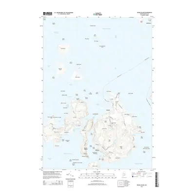
2014 Map of Swans Island
USGS Topo · Published 2014About this map
Swans Island anchors this coastal Maine survey, revealing a landscape defined by its maritime heritage and granite industry. The settlement of Minturn sits along the protected waters of Burnt Point, while the northern village of Richtown is marked by its namesake Richtown Cem. A legacy of stone extraction is evident at the Quarry near Long Cove, a site typical of the island's historical economy. Access to the mainland and neighboring islands is facilitated by the Swans Island Fry and the Bass Harbor-Frenchboro Fry, which connect this isolated terrain to the broader Hancock County coastline. Numerous small graveyards, including Irish Point Cem and Grindle Hill Cem, provide valuable points of interest for genealogical research, situated among topographical landmarks like Stockbridge Hill and Big Mtn.
Find a feature on this map
114 named features on this map. Tap any name to fly to it.
Don’t see what you’re looking for? This feature index may not catch every label — zoom into the map to look around manually.
Map Details
Editions of this 2014 Swans Island Map
This is the sole edition of this map. No revisions or reprints were ever made.
Other maps of this area

1904 · Deer Isle
USGS Topo · 1:62,500

1904 · Mount Desert
USGS Topo · 1:62,500

1904 · Swan Island
USGS Topo · 1:62,500

1904 · Bluehill
USGS Topo · 1:62,500

1905 · Penobscot Bay
USGS Topo · 1:125,000

1942 · Mount Desert
USGS Topo · 1:62,500

1942 · Deer Isle
USGS Topo · 1:62,500

1943 · Swans Island
USGS Topo · 1:62,500

1944 · Blue Hill
USGS Topo · 1:62,500

1944 · Deer Isle
USGS Topo · 1:62,500