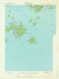
1943 Map of Swans Island
USGS Topo · Published 1966About this map
Great Cranberry Island and the Cranberry Isles anchor the eastern reaches of this coastal survey, where the maritime economy of the 1940s is etched into the shoreline. The map documents the southwestern portion of Mount Desert Island, featuring Acadia National Park land and the settlements of Bernard and Mc Kinley surrounding Bass Harbor. To the west, across Blue Hill Bay, the intricate coastline of Swans Island is revealed, complete with interior features like Stockbridge Pond and the central village. Navigation remains a primary theme of the era, marked by the Blue Hill Bay LH (lighthouse) and the established Ferry to Rockland. From the quiet waters of Mackerel Cove to the southern tip at Bass Harbor Head, the map captures a landscape defined by isolated island communities, sheltered harbors, and early conservation efforts such as the Little Duck I Bird Sanctuary.
Find a feature on this map
124 named features on this map. Tap any name to fly to it.
Don’t see what you’re looking for? This feature index may not catch every label — zoom into the map to look around manually.
Map Details
Editions of this 1943 Swans Island Map
3 editions found
Other maps of this area

1904 · Deer Isle
USGS Topo · 1:62,500

1904 · Mount Desert
USGS Topo · 1:62,500

1904 · Swan Island
USGS Topo · 1:62,500

1904 · Bar Harbor
USGS Topo · 1:62,500

1904 · Bluehill
USGS Topo · 1:62,500

1905 · Penobscot Bay
USGS Topo · 1:125,000

1942 · Bar Harbor
USGS Topo · 1:62,500

1942 · Mount Desert
USGS Topo · 1:62,500

1942 · Deer Isle
USGS Topo · 1:62,500

1943 · Swans Island
USGS Topo · 1:62,500