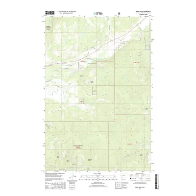
2017 Map of Swede Gulch
USGS Topo · Published 2017About this map
Lincoln serves as the primary settlement hub in this mountain landscape, where the Blackfoot River flows through the upper reaches of the Helena National Forest. The map documents a complex network of mountain roads and gulches that speak to the area's history of ranching and timber. Notable water management is evident through the Grosfield Ditch near Landers Fork, while local geography is defined by numerous family-named and topographic landmarks such as Swede Gulch, Rochester Gulch, and Davis Gulch. High-altitude routes like Stemple Pass Rd and Humbug Contour Rd traverse the steep slopes leading toward Crater Mtn. This record illustrates the intersection of public forest lands and private interests, including the Gehring Ranch Rd, within the drainage basins of Seven-up Pete Cr and the S Fork Humbug Cr.
Find a feature on this map
44 named features on this map. Tap any name to fly to it.
Don’t see what you’re looking for? This feature index may not catch every label — zoom into the map to look around manually.
Map Details
Editions of this 2017 Swede Gulch Map
This is the sole edition of this map. No revisions or reprints were ever made.
Other maps of this area

1889 · Helena
USGS Topo · 1:250,000

1893 · Helena
USGS Topo · 1:250,000

1899 · Helena
USGS Topo · 1:250,000

1903 · Coopers Lake
USGS Topo · 1:125,000

1903 · Helena
USGS Topo · 1:250,000

1943 · Hogan
USGS Topo · 1:125,000

1947 · Butte
USGS Topo · 1:250,000

1955 · Choteau
USGS Topo · 1:250,000

1957 · Choteau
USGS Topo · 1:250,000

1958 · Butte
USGS Topo · 1:250,000