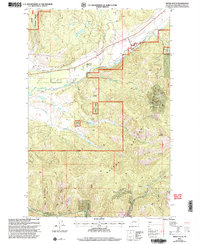
2001 Map of Swede Gulch
USGS Topo · Published 2004About this map
Helena National Forest lands dominate this montane landscape, where the Blackfoot River cuts through the northern terrain. The map details a legacy of resource extraction, with numerous mining operations such as the Columbia Mine, Seven Up Pete Mine, and Silver Bell Mine scattered across the gulches. These industrial sites are concentrated around the drainages of Swede Gulch and Rochester Gulch, illustrating the era's mining footprint within the Lincoln Ranger District. Local ranching and aviation are represented by the Seven Up Pete Ranch and its nearby Airstrip, providing a contrast to the surrounding wilder peaks. Named features like Crater Mountain and Swede Hollow define the physical geography, while several other small-scale operations including the Rover Mine and Swansea Mine offer specific points of interest for those tracing the history of the upper Blackfoot drainage.
Find a feature on this map
26 named features on this map. Tap any name to fly to it.
Don’t see what you’re looking for? This feature index may not catch every label — zoom into the map to look around manually.
Map Details
Editions of this 2001 Swede Gulch Map
This is the sole edition of this map. No revisions or reprints were ever made.
Other maps of this area

1889 · Helena
USGS Topo · 1:250,000

1893 · Helena
USGS Topo · 1:250,000

1899 · Helena
USGS Topo · 1:250,000

1903 · Coopers Lake
USGS Topo · 1:125,000

1903 · Helena
USGS Topo · 1:250,000

1943 · Hogan
USGS Topo · 1:125,000

1947 · Butte
USGS Topo · 1:250,000

1955 · Choteau
USGS Topo · 1:250,000

1957 · Choteau
USGS Topo · 1:250,000

1958 · Butte
USGS Topo · 1:250,000