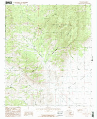
1986 Map of Swede Peak
USGS Topo · Published 1986About this map
Chiricahua Mountains dominate this high-desert landscape in Cochise County, where the transition from steep peaks to broad valleys is documented in high detail. This mid-1980s provisional map details the northeastern portion of the range, centered on the Chiricahua Wilderness and Swede Peak. The topography is defined by a series of dramatic canyons including Tex Canyon, Rustler Canyon, and Mulberry Canyon, which funnel seasonal water toward the lower San Simon Valley and San Bernardino Valley.
Find a feature on this map
25 named features on this map. Tap any name to fly to it.
Don’t see what you’re looking for? This feature index may not catch every label — zoom into the map to look around manually.
Map Details
Editions of this 1986 Swede Peak Map
2 editions found
Other maps of this area

1917 · Chiricahua
USGS Topo · 1:125,000

1919 · Chiricahua
USGS Topo · 1:125,000

1926 · Rodeo
USGS Topo · 1:62,500

1926 · Rucker
USGS Topo · 1:62,500

1926 · Pedregosa
USGS Topo · 1:62,500

1940 · Apache
USGS Topo · 1:62,500

1955 · Douglas
USGS Topo · 1:250,000

1958 · Chiricahua Peak
USGS Topo · 1:62,500

1958 · Apache
USGS Topo · 1:62,500
1958 · Pedregosa Mountains
USGS Topo · 1:62,500