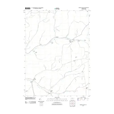
2010 Map of Sweden Valley
USGS Topo · Published 2010About this map
The upper reaches of the Allegheny River wind through Potter County's high country, defining a landscape of narrow valleys and prominent hills. This 2010 survey documents a transition in local geography where the river flows past the small settlements of Colesburg and Frinks. The terrain is characterized by a series of deep hollows named for local families and natural features, including Lent Hollow, Haskell Hollow, and Pigeon Hollow.
Find a feature on this map
59 named features on this map. Tap any name to fly to it.
Don’t see what you’re looking for? This feature index may not catch every label — zoom into the map to look around manually.
Map Details
Editions of this 2010 Sweden Valley Map
This is the sole edition of this map. No revisions or reprints were ever made.
Other maps of this area

1932 · Genesee
USGS Topo · 1:62,500

1934 · Coudersport
USGS Topo · 1:48,000

1937 · Genesee
USGS Topo · 1:62,500

1938 · Coudersport
USGS Topo · 1:62,500

1947 · Conrad
USGS Topo · 1:62,500

1947 · Ayers Hill
USGS Topo · 1:24,000

1947 · Cherry Springs
USGS Topo · 1:24,000

1948 · Emporium
USGS Topo · 1:62,500
1948 · Austin
USGS Topo · 1:24,000
1949 · Ayers Hill
USGS Topo · 1:24,000
Featured Places
- Sweden Township, PA
- Hebron Township, PA
- Allegany Township, PA
- Frinks, Eulalia Township
- Eulalia Township, PA