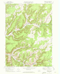
1969 Map of Sweden Valley
USGS Topo · Published 1972About this map
The high plateau of the Susquehannock State Forest dominates this Potter County landscape, where the headwaters of the Allegheny River begin their long journey south and west. Established settlements like Coudersport and Sweden Valley anchor the valley floors, connected by the Coudersport and Port Allegany corridor. The geography of the late 1960s reveals an interesting mix of traditional agriculture and modern industrial infrastructure, characterized by an extensive Underground Gas Storage Field and a network of pipelines traversing the hills.
Find a feature on this map
41 named features on this map. Tap any name to fly to it.
Don’t see what you’re looking for? This feature index may not catch every label — zoom into the map to look around manually.
Map Details
Editions of this 1969 Sweden Valley Map
This is the sole edition of this map. No revisions or reprints were ever made.
Other maps of this area

1932 · Genesee
USGS Topo · 1:62,500

1934 · Coudersport
USGS Topo · 1:48,000

1937 · Genesee
USGS Topo · 1:62,500

1938 · Coudersport
USGS Topo · 1:62,500

1947 · Conrad
USGS Topo · 1:62,500

1947 · Ayers Hill
USGS Topo · 1:24,000

1947 · Cherry Springs
USGS Topo · 1:24,000

1948 · Emporium
USGS Topo · 1:62,500
1948 · Austin
USGS Topo · 1:24,000
1949 · Ayers Hill
USGS Topo · 1:24,000
Featured Places
- Sweden Township, PA
- Hebron Township, PA
- Lymansville, Coudersport
- Sweden Valley, Sweden Township
- Allegany Township, PA