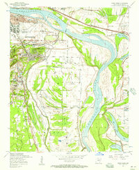
1954 Map of Sweet Home
USGS Topo · Published 1957About this map
Fourche Island dominates this mid-1950s survey of the Arkansas riverfront, where agricultural lowlands meet the expanding urban reach of Little Rock. The map illustrates a landscape in transition, featuring the growing Municipal Airport at Adams Field alongside the established community of College Station. Industry and infrastructure are evident in the sprawling rail networks of the Missouri Pacific and St Louis Southwestern railroads, while local economic life is anchored by facilities like Browns Gin and several strip mines near Granite Mountain. Numerous rural congregations, including Higgins Church and Bethel Church, are scattered across the terrain, reflecting the social fabric of settlements like Sweet Home and Higgins. The intricate winding of Fourche Bayou and the Arkansas River define the local geography, providing a clear view of the region's complex water network before later modern development.
Find a feature on this map
55 named features on this map. Tap any name to fly to it.
Don’t see what you’re looking for? This feature index may not catch every label — zoom into the map to look around manually.
Map Details
Editions of this 1954 Sweet Home Map
This is the sole edition of this map. No revisions or reprints were ever made.
Other maps of this area

1891 · Little Rock
USGS Topo · 1:125,000

1893 · Little Rock
USGS Topo · 1:125,000

1935 · Mc Almont
USGS Topo · 1:24,000

1935 · Little Rock
USGS Topo · 1:24,000

1935 · Sweet Home
USGS Topo · 1:24,000

1935 · North Little Rock
USGS Topo · 1:24,000

1935 · Alexander
USGS Topo · 1:48,000

1939 · Keo
USGS Topo · 1:31,680

1940 · Woodson
USGS Topo · 1:31,680

1941 · Alexander
USGS Topo · 1:62,500