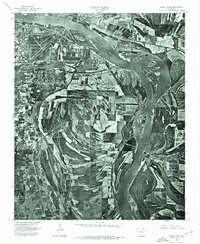
1975 Map of Sweet Home
USGS Topo · Published 1976About this map
The Arkansas River carves a sweeping path through this mid-1970s orthophotomap, defining the physical and economic boundary between Little Rock and North Little Rock. Unlike traditional topographic maps, this aerial mosaic reveals the fine-grained texture of the mid-century Arkansas landscape, from the dense urban grid and runways in the northwest to the intricate patchwork of agricultural fields and riverine wetlands further south. The small community of Sweet Home sits at the edge of this transition, where the developed city begins to give way to the shifting sandbars and broad meanders of the river. This aerial perspective is particularly valuable for researchers tracing the evolution of the river's banks and the industrial expansion of the capital region before the intensification of modern suburban development.
Find a feature on this map
4 named features on this map. Tap any name to fly to it.
Don’t see what you’re looking for? This feature index may not catch every label — zoom into the map to look around manually.
Map Details
Editions of this 1975 Sweet Home Map
This is the sole edition of this map. No revisions or reprints were ever made.
Other maps of this area

1891 · Little Rock
USGS Topo · 1:125,000

1893 · Little Rock
USGS Topo · 1:125,000

1935 · Mc Almont
USGS Topo · 1:24,000

1935 · Little Rock
USGS Topo · 1:24,000

1935 · Sweet Home
USGS Topo · 1:24,000

1935 · North Little Rock
USGS Topo · 1:24,000

1935 · Alexander
USGS Topo · 1:48,000

1939 · Keo
USGS Topo · 1:31,680

1940 · Woodson
USGS Topo · 1:31,680

1941 · Alexander
USGS Topo · 1:62,500