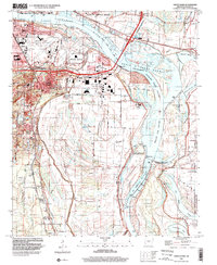
1994 Map of Sweet Home
USGS Topo · Published 2000About this map
The Arkansas River dictates the landscape south of Little Rock, where industrial development and historical settlements meet the river's shifting curves. This late twentieth-century data shows the expansion of the Little Rock Port Industrial Park and the extensive infrastructure of Adams Field Municipal Airport. Away from the urban core, the map preserves the locations of vital community centers like College Station, Sweet Home, and Wrightsville, as well as rural landmarks such as Mt Carmel Ch and Carver Sch. The complex hydrology of the river basin is evident in features like the Willow Bar Cut-Off and David D Terry Lake, reflecting decades of navigation and flood control efforts that reshaped Peach Orchard Bend and Gates Island.
Find a feature on this map
53 named features on this map. Tap any name to fly to it.
Don’t see what you’re looking for? This feature index may not catch every label — zoom into the map to look around manually.
Map Details
Editions of this 1994 Sweet Home Map
This is the sole edition of this map. No revisions or reprints were ever made.
Other maps of this area

1891 · Little Rock
USGS Topo · 1:125,000

1893 · Little Rock
USGS Topo · 1:125,000

1935 · Mc Almont
USGS Topo · 1:24,000

1935 · Little Rock
USGS Topo · 1:24,000

1935 · Sweet Home
USGS Topo · 1:24,000

1935 · North Little Rock
USGS Topo · 1:24,000

1935 · Alexander
USGS Topo · 1:48,000

1939 · Keo
USGS Topo · 1:31,680

1940 · Woodson
USGS Topo · 1:31,680

1941 · Alexander
USGS Topo · 1:62,500