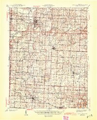
1945 Map of Sweet Springs
USGS Topo · Published 1945About this map
The Blackwater River winds through this Central Missouri landscape, defining the rural character of the borderlands between Saline, Pettis, Johnson, and Lafayette counties. Based on surveys from 1938-39, the map reveals a densely settled agricultural region anchored by the Missouri Pacific railroad corridor. This rail line connects the southern settlements of La Monte, Dresden, and Hughesville, while the northern portion of the quadrangle is dominated by Sweet Springs and the mineral waters of McAllister Springs. The era's educational and spiritual infrastructure is remarkably detailed, with dozens of family-named institutions like the Rose Valley Sch, Oak Grove Sch, and Prairie Hill Ch serving scattered farmsteads. The presence of Bleak Mound and various creek branches such as Davis Creek and Heath Creek illustrates a terrain where natural topography dictated the placement of early Missouri homesteads and post offices.
Find a feature on this map
77 named features on this map. Tap any name to fly to it.
Don’t see what you’re looking for? This feature index may not catch every label — zoom into the map to look around manually.
Map Details
Editions of this 1945 Sweet Springs Map
2 editions found

Other maps of this area

1885 · Warrensburg
USGS Topo · 1:125,000

1887 · Sedalia
USGS Topo · 1:125,000

1887 · Warrensburg
USGS Topo · 1:125,000

1889 · Lexington
USGS Topo · 1:125,000

1890 · Marshall
USGS Topo · 1:125,000

1892 · Marshall
USGS Topo · 1:125,000

1894 · Sedalia
USGS Topo · 1:125,000

1894 · Warrensburg
USGS Topo · 1:125,000

1901 · Marshall
USGS Topo · 1:125,000

1917 · Knobnoster
USGS Topo · 1:62,500