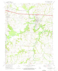
1973 Map of Sweet Springs
USGS Topo · Published 1975About this map
The Blackwater River and its numerous tributaries, including the South Fork Blackwater River, dominate this West Central Missouri landscape. The town of Sweet Springs serves as the primary hub, where the Missouri Pacific rail line and Sweet Springs Park are central features. To the west, the settlement of Emma sits near the Lafayette-Saline county line, while the southern reaches show the rural community of Dunksburg at the junction of several county boundaries.
Find a feature on this map
35 named features on this map. Tap any name to fly to it.
Don’t see what you’re looking for? This feature index may not catch every label — zoom into the map to look around manually.
Map Details
Editions of this 1973 Sweet Springs Map
This is the sole edition of this map. No revisions or reprints were ever made.
Other maps of this area

1885 · Warrensburg
USGS Topo · 1:125,000

1887 · Sedalia
USGS Topo · 1:125,000

1887 · Warrensburg
USGS Topo · 1:125,000

1889 · Lexington
USGS Topo · 1:125,000

1890 · Marshall
USGS Topo · 1:125,000

1892 · Marshall
USGS Topo · 1:125,000

1894 · Sedalia
USGS Topo · 1:125,000

1894 · Warrensburg
USGS Topo · 1:125,000

1901 · Marshall
USGS Topo · 1:125,000

1917 · Knobnoster
USGS Topo · 1:62,500