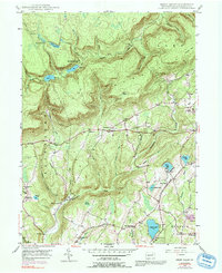
1946 Map of Sweet Valley
USGS Topo · Published 1991About this map
North Mountain and the Fairmount Hills dominate this mid-century landscape in Luzerne County, where small agricultural and timber communities were connected by a network of winding valley roads. The settlement of Mountain Springs is situated near the Splash Dam and Dam No 2, indicating the area's history of water management for logging or industrial use. Along the central corridor, the village of Kyttle serves as a local hub, home to the Retreat Sch and Mooretown Ch.
Find a feature on this map
53 named features on this map. Tap any name to fly to it.
Don’t see what you’re looking for? This feature index may not catch every label — zoom into the map to look around manually.
Map Details
Editions of this 1946 Sweet Valley Map
4 editions found

Other maps of this area

1891 · Harveys Lake
USGS Topo · 1:62,500

1893 · Harvey Lake
USGS Topo · 1:62,500

1894 · Shickshinny
USGS Topo · 1:62,500

1894 · Bloomsburg
USGS Topo · 1:62,500

1934 · Laporte
USGS Topo · 1:62,500

1946 · Nanticoke
USGS Topo · 1:31,680

1946 · Shickshinny
USGS Topo · 1:31,680

1946 · Dutch Mtn
USGS Topo · 1:24,000

1946 · Harveys Lake
USGS Topo · 1:24,000

1946 · Noxen
USGS Topo · 1:24,000
Featured Places
- Hunlock Township, PA
- Prichard, Hunlock Township
- Lake Township, PA
- Sweet Valley, Ross Township
- Ripple, Fairmount Township