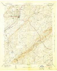
1942 Map of Sweetwater
USGS Topo · Published 1942About this map
Sweetwater serves as the hub of this East Tennessee landscape, where the campus of the Tennessee Military Institute stands prominently north of the town center. The early 1940s topography reveals a well-developed network of small communities and rural institutions, from Christianburg in the south to the hillside settlement at Northpoint. The Southern railroad line parallels the Lee Highway through the valley, anchoring the local economy to the transport corridor between Watson Ridge and Blackoak Ridge.
Find a feature on this map
39 named features on this map. Tap any name to fly to it.
Don’t see what you’re looking for? This feature index may not catch every label — zoom into the map to look around manually.
Map Details
Editions of this 1942 Sweetwater Map
2 editions found
Other maps of this area

1886 · Cleveland
USGS Topo · 1:125,000

1887 · Kingston
USGS Topo · 1:125,000

1891 · Kingston
USGS Topo · 1:125,000

1892 · Cleveland
USGS Topo · 1:125,000

1893 · Murphy
USGS Topo · 1:125,000

1893 · Kingston
USGS Topo · 1:125,000

1895 · Cleveland
USGS Topo · 1:125,000

1895 · Loudon
USGS Topo · 1:125,000

1901 · Cleveland
USGS Topo · 1:125,000

1914 · Murphy
USGS Topo · 1:125,000