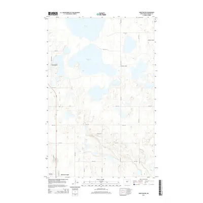
2014 Map of Sweetwater
USGS Topo · Published 2014About this map
Morrison Lake and Sweetwater Lake dominate this Ramsey County landscape, illustrating the intricate hydrology of the northern plains. The settlement of Sweetwater sits along the western edge, positioned near the junction of Sweetwater Dr and ND-20. To the south, the map captures the northern fringes of the Devils Lake basin and the campus of Lake Region State Coll, highlighting the area's role as a regional hub. The terrain is further defined by Edmore Coulee, which meanders through the eastern sections, while a precise grid of rural roads like 85th Ave NE and 53rd St NE provides access to the agricultural tracts between the water bodies. This 2014 survey records the modern road network, including residential developments like Crystal Lane Ct, amidst the enduring prairie wetland geography.
Find a feature on this map
23 named features on this map. Tap any name to fly to it.
Don’t see what you’re looking for? This feature index may not catch every label — zoom into the map to look around manually.
Map Details
Editions of this 2014 Sweetwater Map
This is the sole edition of this map. No revisions or reprints were ever made.
Other maps of this area

1931 · Devils Lake
USGS Topo · 1:62,500

1950 · Devils Lake
USGS Topo · 1:62,500

1951 · Crary
USGS Topo · 1:24,000

1951 · Devils Lake
USGS Topo · 1:24,000

1951 · Grand Harbor
USGS Topo · 1:24,000

1951 · Camp Grafton
USGS Topo · 1:24,000

1951 · Sweetwater
USGS Topo · 1:24,000

1953 · Devils Lake
USGS Topo · 1:250,000

1956 · Devils Lake
USGS Topo · 1:250,000

1957 · Starkweather SE
USGS Topo · 1:24,000