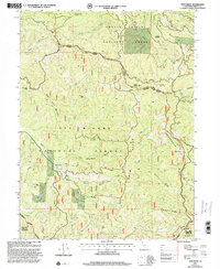
1997 Map of Swim Ridge
USGS Topo · Published 2001About this map
Shasta Trinity National Forest and Six Rivers National Forest meet in this late-twentieth-century study of the California wilderness. The terrain is defined by the high crests of Swim Ridge and Horsehead Ridge, which flank the complex drainage systems of the Mad River and the South Fork Mad River. Evidence of early resource extraction persists in the landscape through the Bonanza Mine and Lucky Sunday Mine, both situated within the steep canyons of the Trinity and Humboldt county border area. The mapping highlights a specialized infrastructure of forest management, including the Yolla Bolly Mad River Trail and the Mad River Road, which provided access to remote peaks such as North Kelsey Peak and South Kelsey Peak. This region, partly protected within the Yolla Bolly-Middle Eel Wilderness, serves as a critical watershed where numerous gulches and springs, such as Happy Camp Spring and Waterspout Spring, feed the primary river systems.
Find a feature on this map
46 named features on this map. Tap any name to fly to it.
Don’t see what you’re looking for? This feature index may not catch every label — zoom into the map to look around manually.
Map Details
Editions of this 1997 Swim Ridge Map
This is the sole edition of this map. No revisions or reprints were ever made.
Other maps of this area

1918 · Anada
USGS Topo · 1:62,500

1921 · Hoaglin
USGS Topo · 1:62,500

1922 · Island Mountain
USGS Topo · 1:62,500

1931 · Hoaglin
USGS Topo · 1:96,000

1935 · Hoaglin
USGS Topo · 1:125,000

1953 · Blackrock Mtn
USGS Topo · 1:62,500

1954 · Pickett Peak
USGS Topo · 1:62,500

1954 · Dubakella Mtn
USGS Topo · 1:62,500

1954 · Blackrock Mtn
USGS Topo · 1:62,500
1955 · Kettenpom
USGS Topo · 1:62,500