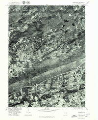
1976 Map of Sybertsville
USGS Topo · Published 1979About this map
Nescopeck Mountain dominates this mid-1970s orthophotoquad, creating a massive wooded divide between the agricultural valleys of southern Luzerne County. This specialized imagery, produced by the Geological Survey in cooperation with the Soil Conservation Service, uses October 1976 aerial photography to provide a clear view of the regional land-use patterns of the era. The small settlements of Sybertsville and Conyngham anchor the southern portion of the sheet, where residential clusters sit adjacent to structured field patterns. To the north, the smaller hamlets of Hobbie and Dorrance are interspersed among a complex network of woodlots and farms. The distinct grain of the landscape is defined by the underlying geology, which funneling drainage through the unnamed Creek and surrounding watershed, illustrating the persistent influence of the ridge-and-valley terrain on Pennsylvania development.
Find a feature on this map
6 named features on this map. Tap any name to fly to it.
Don’t see what you’re looking for? This feature index may not catch every label — zoom into the map to look around manually.
Map Details
Editions of this 1976 Sybertsville Map
This is the sole edition of this map. No revisions or reprints were ever made.
Other maps of this area

1889 · Hazleton
USGS Topo · 1:62,500

1891 · Wilkesbarre
USGS Topo · 1:62,500

1891 · Hazleton
USGS Topo · 1:62,500

1892 · Mahanoy
USGS Topo · 1:62,500

1893 · Hazleton
USGS Topo · 1:62,500

1893 · Mahanoy
USGS Topo · 1:62,500

1894 · Shickshinny
USGS Topo · 1:62,500

1894 · Wilkesbarre
USGS Topo · 1:62,500

1943 · Scranton
USGS Topo · 1:125,000

1944 · Newark
USGS Topo · 1:250,000
Featured Places
- Dorrance Township, PA
- Conyngham Township, PA
- Slocum Township, PA
- Nescopeck Township, PA
- Butler Township, PA