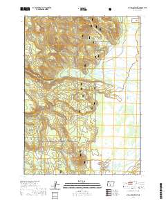
2020 Map of Sycan Marsh West
USGS Topo · Published 2020About this map
Sycan Marsh dominates the eastern half of this landscape, creating a vast wetland system within the high country of Lake County. This 2020 survey by the U.S. Geological Survey illustrates the complex hydrology of the region, where water bodies like Coyote Cr and Long Cr feed into the marshlands. To the south, the Sycan Wild and Scenic River flows through the protected reaches of the Fremont National Forest, highlighting a transition from open wetlands to timbered slopes. Notable water sources such as Cold Spring and the drainage of Dry Cr are clearly marked, providing essential data for those studying the environmental management and natural history of this preserved Oregon wilderness. The map is particularly useful for understanding the modern boundary of the national forest and the intricate network of streams that define this specific quadrangle.
Find a feature on this map
11 named features on this map. Tap any name to fly to it.
Don’t see what you’re looking for? This feature index may not catch every label — zoom into the map to look around manually.
Map Details
Editions of this 2020 Sycan Marsh West Map
This is the sole edition of this map. No revisions or reprints were ever made.
Other maps of this area

1889 · Klamath
USGS Topo · 1:250,000

1894 · Klamath
USGS Topo · 1:250,000

1955 · Klamath Falls
USGS Topo · 1:250,000

1958 · Klamath Falls
USGS Topo · 1:250,000

1960 · Riverbed Butte
USGS Topo · 1:62,500

1960 · Sycan Marsh
USGS Topo · 1:62,500

1960 · Fuego Mountain
USGS Topo · 1:62,500

1960 · Yamsay Mountain
USGS Topo · 1:62,500

1980 · Williamson River
USGS Topo · 1:100,000
1988 · Sycan Marsh West
USGS Topo · 1:24,000