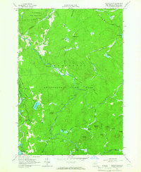
1964 Map of Sylvan Falls
USGS Topo · Published 1966About this map
The West Branch St Regis River carves through this mid-1960s landscape, punctuated by Sylvan Falls and the secluded Oboperage Club. This area of St. Lawrence County is defined by its water and timber resources, spanning from the St Lawrence State Forest No 8 to the western edge of Adirondack State Park. The river system’s industrial and recreational utility is evident in features like the Gaging Station and the Blake Falls Reservoir on the Raquette River.
Find a feature on this map
63 named features on this map. Tap any name to fly to it.
Don’t see what you’re looking for? This feature index may not catch every label — zoom into the map to look around manually.
Map Details
Editions of this 1964 Sylvan Falls Map
This is the sole edition of this map. No revisions or reprints were ever made.
Other maps of this area

1908 · Potsdam
USGS Topo · 1:62,500

1919 · Nicholville
USGS Topo · 1:62,500

1920 · Childwold
USGS Topo · 1:62,500

1921 · Childwold
USGS Topo · 1:48,000

1921 · Nicholville
USGS Topo · 1:62,500

1921 · Stark
USGS Topo · 1:62,500

1922 · Childwold
USGS Topo · 1:62,500

1923 · Stark
USGS Topo · 1:62,500

1940 · Stark
USGS Topo · 1:62,500

1942 · Long Bow
USGS Topo · 1:24,000